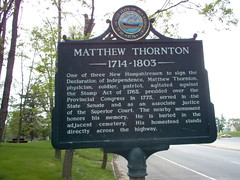
Matthew Thornton (1714-1803) New Hampshire graveyard sign
Originally uploaded by marcn.
Geotagging is a way to tag your photos with a latitude/longitude on flickr.com and have them mapped using Google Maps.
geobloggers.com just does that.
Basically you add the tags "geotagged", "geo:lat=xx.xxxx" and "geo:lon=xx.xxxx" to a photo and optionally (but I've not see it work otherwise) put a link to geobloggers.com in the photo description.
When you click on the link, it will show that photo on a zoomable google map.
This afternoon Griffin and I took some photos around Matthew Thornton's gravesite. Drill down can you can see the relative location of all the gravestones. Don't know who Matthew Thornton was?
I'm trying to convince Spencer and Griffin geotagging a cemetery closer to the house would make
a great summer project -- using digital camera, GPS, using the PC, helping genealogists, and of course, the possibility of fame -- hopefully will be enough to get them interested.